GPS units and navigation apps are fantastic aids until their batteries die. If you get stuck in the woods with no hand-held power, you’ll be fine if you can navigate with a map and compass. Navigational skills are also handy for areas where cellular or satellite signals are weak.
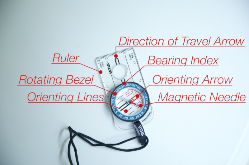
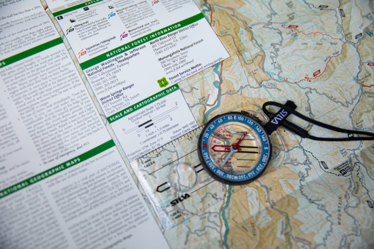
Study the parts of a compass and their function. Photo Credit: ATA
You’ll need these basics to navigate without electronic devices: a sighting compass, a scaled map of your hunting area, and something to mark your map.
A sighting compass has many features you’ll need to set accurate courses and measure how far you must travel.
The above diagram shows a compass and its parts. Let’s discuss what each part does.
Point the compass’s direction-of-travel arrow in the direction you want to go. The bezel rotates and has 360-degree markings. The number that aligns with the index line is your bearing. Turn the bezel to align your compass’s orienting lines with the map’s lines that run north to south. Use the rulers on the compass’s base in conjunction with your map’s scale to measure distances.
Don’t worry if you feel puzzled at first. Compass features become increasingly clear as you use them.
Make sure you know how to find a bearing. Photo Credit: ATA
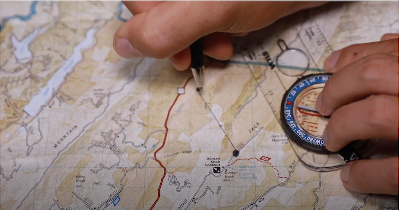
A fundamental skill for navigating with a map and compass is taking a bearing — the specific direction you’ll follow to navigate between two points.
Do you need a map? Download and print free maps here. To take a bearing, lay your map on a flat surface and place your compass on it. Mark your current position on the map and where you want to go, and then draw a line between the two points. Place the straight edge of the compass’s base along the line, and point its direction-of-travel arrow in the direction you want to go.
Rotate the bezel until the orienting lines align with the grid lines running north to south on the map. The north marker on the compass’ bezel should point north on the map. The number that aligns with your index line is your bearing.
To follow that bearing, turn your body until the needle is inside the orienting arrow. The direction-of-travel arrow now points toward your destination.
Before you start hiking, account for magnetic declination. Your compass points to magnetic north, which varies from true north. Declination is the difference between true and magnetic north. If you don’t account for it, the difference can send you far off course. For example, 10 degrees can make you miss your mark by 920 feet (over 306 yards) for every mile hiked.
How do you find declination? It varies by location, but you can find it on your map or look it up here.
In western Virginia, the declination is 9 degrees west. Therefore, the bearing for due north is not zero degrees. It’s 351 degrees. To account for declination, go through the steps we discussed to get your bearing, and then rotate the bezel 9 degrees west to get your true bearing.
To avoid doing this math, buy a compass with adjustable declination. You’ll then calibrate the compass before your trip so your bearings read true. Declinations change over time, so you must recalibrate every few years.
Identify landmarks you can use if you get lost. Photo credit: ATA
To find your bearing, you must know where you are and where you’re going. What must you do if you’re lost? Find your location on the map by using landmarks and bearings to triangulate your position.
Find a landmark like a body of water, mountain peak, geographic feature, or two intersecting trails. Point the direction-of-travel arrow at the landmark, and rotate the bezel until the needle is inside the orienting arrow. Read the bearing at the index line.
Find the landmark on the map, and put the compass’s corner on the landmark. Rotate the compass until the orienting lines point north-south. Draw a line using the edge of the compass’s base as your guide.
Repeat this process with at least two other landmarks. Where the lines intersect is your location.
Practice taking bearings and triangulating your location in a familiar environment. These basic navigation skills become easier through practice Once you master them, you can try advanced methods that achieve pinpoint navigation over vast distances.